
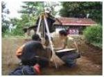
GPS Survey for the study of fault activity Baribis Nov, 2007 – KK Geodesy
In early November 2007, the Scientific Group of Geodesy through research funding ITB GPS observations when the second for the study program Baribis Fault activity by utilizing GPS technology. As it is known that the Fault Baribis are in some areas were quite full of people such as the Duchy, Maja, Talaga, Cikijing, and other areas. Therefore, research on fault activity is clearly necessary, because according to some records, the area has the potential Baribis fault seismicity. GPS technology can see the geometric characteristics of the dynamics around the fault, then subsequently be used as a parameter in the determination of fault activity model.
More information on http://geodesy.gd.itb.ac.id
No Comments